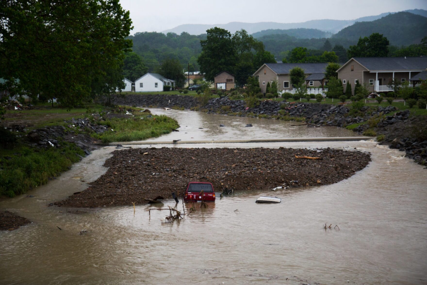
Six years have passed since the 2016 flood in southern West Virginia that killed 23 people and ravaged communities like White Sulphur Springs and Rainelle. Despite that, researchers say the state does not have a long-term flood recovery plan.
Reporter Shepherd Snyder spoke with WVU researcher and assistant professor of geography Jamie Shinn on her project studying how residents of Greenbrier County recovered from the flood, and how the results could shape more effective flood responses both at the state and national levels in the future.
Snyder: Getting started, I was wondering if you could tell me about this research project and what the research process will look like.
Shinn: We’ll be focusing on two towns within Greenbrier County: Rainelle and White Sulphur Springs. And we’ll be engaging with community members through a variety of tools. So we’ll do a countywide survey that any resident over the age of 18 is welcome to take, we’ll do some more targeted focus groups with people who were involved in both the response and recovery to the flood as well as impacted by the flood. And then we’ll take some interviews with people at regional, state and national levels who were involved or represent organizations that were involved in flood response and recovery. And our goal in doing that is to answer three research questions.
We’re now several years out from the flood. And yet we know that communities are continuing to deal with the lingering impacts in the recovery process. What we’ve been told by people on the ground is that we have yet to systematically document the lessons learned from the flood, how response in recovery went, what went well, what could have gone better, so that we can better prepare for future floods. And we only need to look as far as Eastern Kentucky in recent months to know that these types of things are likely to happen again in the region. And so we have kind of three overarching goals with the stage one project. The first is to identify gaps in organizational capacity that we can fill to create a more robust flood response and long term recovery. So what do local first responders need to be equipped to respond as quickly and as effectively as possible? What do community and county level groups need? And what do national level groups need? How can we make sure that every group at every scale has the best capacity possible to respond? And then what is the cross-organizational capacity building and coordination that we can do between these groups?
So for instance, in the 2016 flood, we know that all sorts of actors responded, we had voluntary first responders, trained first responders, National Guard, FEMA, Red Cross but also a huge amount of volunteers coming in and faith based organizations. We have the Appalachian service project, we have the Mennonite disaster committee, who spent years in these communities helping to rebuild and respond. Our question is, is there a better way, we can in advance coordinate among these groups to make sure that our response and recovery is as effective and efficient as possible in the future?
The third question that we’re trying to answer is, what knowledge do people need that they don’t have access to, to best plan for these events? And so for that, we’re working with our partners at the West Virginia GIS Technical Center, which is a state organization that’s housed here at WVU, to do a participatory GIS mapping exercise, where these GIS experts are going to present and also build new flood risk tools. So these might look like flood risk maps, or 3D imaging of what a particular part of town will look like under different flood scenarios. We would bring these to the community focus groups and ask people to respond to them (with questions like): “Are they useful? Do they contain the information they need? Are they user friendly?” And then come back to the drawing board and re-create these tools with that feedback in mind.
So the stage two vision that we’ll propose to the National Science Foundation in the spring is to use whatever we learned in stage one through these different methods. So from the survey from the focus groups, from interviews, from the mapping, to build out what we’re calling the West Virginia Flood Resilience Framework. And the vision for the framework is that it will be an online toolkit accessible to anybody to use. This could be for residents, but it could also be for local government agencies, nonprofits or the state resilience office.
Snyder: Can you give me some context for why this project is needed? And why is it getting off the ground now? How are state and local communities currently responding to these types of disasters?
Shinn: I think it’s so place dependent. One thing we’re fairly cautious of in this project is that this will not be a one-solution-fits-all kind of thing. No county, no town is going to respond the same as another because of the particular context of that place. However, we also know that there are broad lessons that we hope we can apply right across the board. One of the reasons we’ve selected both Rainelle and White Sulphur Springs is because they’ve had really different experiences with flood recovery. Arguably, White Sulphur Springs has recovered at a faster and maybe more complete rate than Rainelle. And largely, we think that’s because White Sulphur Springs has a different socioeconomic context. The presence of the Greenbrier and longer term histories of engagement with the tourism economy has made it so that Rainelle was in a more vulnerable position before the flood than White Sulphur Springs was. And so our hypothesis is that that made it harder for Rainelle to recover.
Other work that I’ve done in Rainelle, one thing I’m hearing from people is that while flood recovery was ongoing since 2016, the COVID-19 pandemic came and further slowed that down. So one question that we’re asking is, how do these compounding disasters work together to keep people from making a full and complete recovery, whether that’s Rainelle or a town elsewhere?
Going back to your first part of your question, the project really grows out of some long term research that I’ve been doing in these two towns. I first started to do some research in both of these towns in 2017, just under a year after the flood. And what really struck me coming out of that research was, in many ways, these towns held some very stereotypical story about a vulnerable Appalachian place that we often hear about; vulnerable before the flood, high rates of unemployment, all of the things I think people think they know about this place. But what stood out to me was not that – though those are very real issues of vulnerability, what stood out to me were also the real sources of resilience that I saw in these communities. So the ways in which neighbors came together, through processes of mutual aid, from rescuing each other from their attic, to mucking out a neighbor’s home before they mucking out their own, to people pouring in from surrounding towns and counties to assist strangers, that these stories were born out of hardship, but were quite beautiful. And then also people’s sense of place – their deep ties to their community, and to the place in which they live, and the desire to rebuild these towns that they’re so attached to. And I think those represent real sources of resiliency that we don’t often talk about when we talk about these places.
And so one question I have is: can we leverage these sources of resiliency into our disaster planning? We know that neighbors are going to help each other, we know that people have a deep commitment to their communities and places despite the hardships, despite the vulnerabilities. And how can we craft a response that kind of honors and recognizes that about these places? That’s been a long term question of mine from working in this area since just after the flood, and something that I’ve seen kind of reappear as well throughout the pandemic and ways in which people have responded to that.
Snyder: You specialize in researching social vulnerability and climate change adaptation. How does that perspective affect this research project in particular?
Shinn: Well, we know from climate models that we expect West Virginia to get wetter, we know broadly that we expect more frequent intensity in precipitation events leading to flooding. And so while we hope there’s never a flood, like the one in 2016, we know that statistically, it’s very likely that there will be. So how can we plan ahead for that? How can we work under that reality?
One thing that the West Virginia GIS Technical Center is doing with this project is using those models to think through risk. So you may have been flooded in 2016 and you may have raised your home in accordance with FEMA regulations. And yet, is that enough to protect you from the flood scenarios that we’re seeing from the climate models that we have access to? And in some cases, the answer is yes. But in some cases, the answer is no. And so that’s exactly the type of knowledge we want to give to communities so that they can start to plan for the response to what we think is inevitable increased intensity and frequency of flooding as a result of climate change. And West Virginia is no stranger to flooding, right? This is not a new story. But we expect that this story will become more common in the future.
Snyder: What is the end goal of this project? What are you and your team hoping to achieve? And how do you think this could affect how we prepare for flooding, both in the state, as well as, you mentioned earlier, both local and even national communities in the future?
Shinn: I hope what it does is show us the resources we already have available and how to use them most effectively. And that it shows us the gaps that we need to fill to be able to respond holistically to long term flood response and recovery. And that isn’t just about what happens on the day of a flood or the months that follow the flood. It has to do with making communities more resilient in advance of the flood. One of our key partners on the ground is the metal River Valley Association. And they’re a group that arose out of the 2016 flood and the recovery efforts, but are really geared at building development, economic resiliency in these communities. Because we know that if a community has resiliency in advance of a natural disaster, whether it’s a flood, or a landslide, or a fire or whatever it might be, we know that their capacity to recover from that is higher. And so I think this project will give us very specific information about what the gaps are, and my hope is then that the tools we create out of this will help people to fill those gaps and think through how to do this. And again, in a way that can be very specific to towns and to the state of West Virginia, but I think we’ll have broad relevance as people start to think about disaster response across the country, regardless of what that disaster is.